Not even going to bother wasting space with the other boring runs I did this week, all easy 3-5 miles - simultaneous trying to recover from the Loveland/Bakerville traverse and get ready for this weekend.. Highlights were my buddy Nir forgetting his running clothes and going in cargo shorts and a polo and Mr. Krupicka following me into physical therapy. But I did do one thing kinda cool this week I guess. And I have a fair amount to say about it, and some pretty sweet pictures if I may be so bold.
Firstly, I want to explain why I ditched Pikes. Pikes seemed last year to be the greatest thing, but when it was right on my doorstep I wasn't excited - at all. The thing is that I wanted to
race Pikes; doing that on my own sounds like the biggest sufferfest imaginable (and not the kind I like!). Furthermore, the scenery on Pikes is (in my opinion) largely inferior to a lot of other areas in Colorado. Now what else did I want to do this summer? The 4-Passes loop! The timing is perfect right now, snow has melted and wildflowers are exploding.
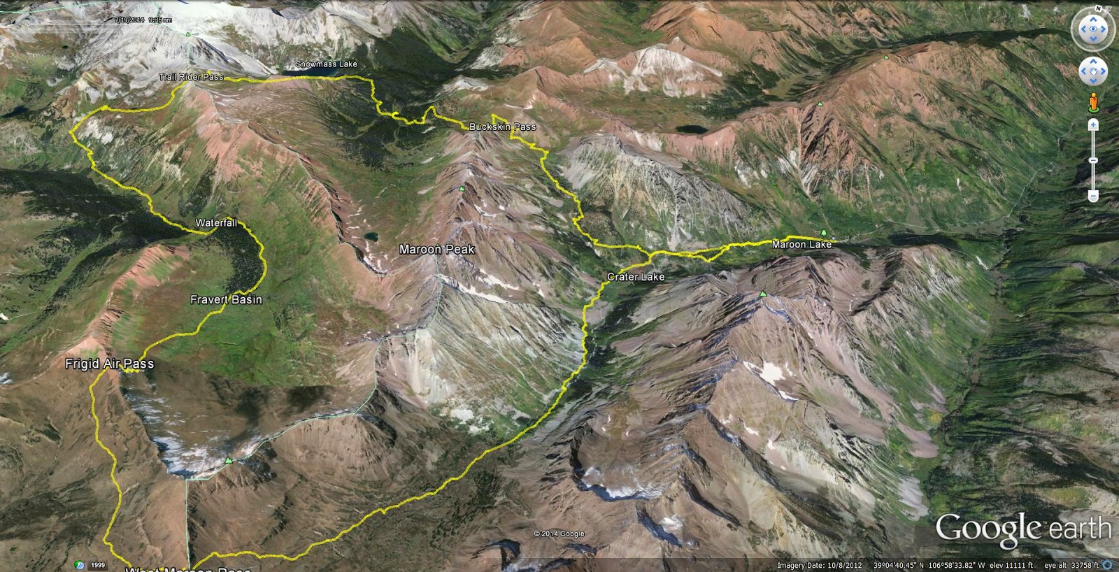
As a preface, this loop - the entire area really - is infamous. What are the Maroon Bells? A quick glance up from Maroon Lake exposes an
image wildly popularized yet not often geographically credited. The Bells are dangerous, beautiful and inspiring. The Four Passes Loop takes the traveler on an orbit around the peaks over four 12,000'+ passes with startling views of the surrounding Elk range. A few names of prior runners on this loop: Anton Krupicka (4:46), Rickey Gates (4:35), and Lance Armstrong (5:40). Most recently Sage Canaday established a near unfathomable time standard of
4:27. Unfortunately, if one wants to keep pace with any of these celebrity athletes, the "easiest" (or should I say "least difficult") is Lance Amrstrong. Well, if you care to know more I'm sure you've heard of Google.
I headed up Friday afternoon enjoying the parking lot on I-70 before bouncing over Independence Pass taking me just outside of the plush city of Aspen. Plenty of five-star hotels around this wealthy area, though I found the trunk of my car offered the best service around - complete with no amenities. After some minor route-finding issues on Tonahutu, I intensely studied (and printed off) the map though its a pretty simple concept: go around that hard to miss colossal mountain. From other reading I gleaned that counter-clockwise was the way to go, as to "enjoy" a pleasant downhill for the last 4 miles off of West Maroon Pass. I also made sure to pack
some (I'll get to that later) calories this time. Looking back, Tonahutu was really just a disaster!
 |
| Ding-Dong, its the bells! |
Started off as soon as it was bright enough to not need a light and made quick work of the gradual incline past Maroon Lake and subsequently Crater Lake. After the turnoff to Buckskin pass I passed one large group of ladies, then traded off leading with a couple of other girls (Usually I never see girls, but today I was the minority). They also had never done the loop, though were more accomplished and experienced "ultrarunners" than I am. I really hate the word "ultra-runner" and "ultra-marathon" it sounds so arrogant and pompous. Anyways, we talked briefly before I headed down Buckskin's west side. One pass and 3,000' done.
 |
| Cascading waterfall on the Buckskin's East side |
 |
| A pretty view of (let to right) Pyramid Peak (14,018'), North Maroon Peak (14,014), Maroon Peak (14,156'), Sleeping Sexton (13,460'), and Pt 13,039'- I checked the map |
 |
| West side of Buckskin Pass which drops down to Snowmass Creek |
I find it especially important for me to push downhills, because I'm learning that its my only real qualifiable strength in trail running. I slithered down the winding trail passing a pond...or two, who knows I saw a lot of things! Eventually the trail dumped me into a swamp with no obvious direction to head. I pulled out my trusty map and I appeared to be in the right place, yet there was certainly
nowhere to go. Eventually the two girls caught back up, they immediately decided to backtrack a bit, and we found a turnoff about 50ft back up the trail that cleanly crossed a waterfall on a log bridge. Nice. They stopped here to refill water as I continued on towards Trail Rider Pass.
 |
| Just before the bridge with another nice view of the Bells. |
Popping out of treeline for the second time, my eyes welcomed the sight of Snowmass Mountain (14.092') and Snowmass Lake. After tromping through some Cordis height willows it was grassy switchbacks to the top of the pass. The girls gave chase from behind but could never make up the distance (that will change later). We talked about running shoes (typical) and had a bit to eat at the top of Trail Rider Pass before I led the charge down the opposite side of the pass. These pictures are so cool and they don't even fully capture the beauty! Two passes down.
 |
| Snowmass Lake with some peak I can't identify on the Snowmass massif |
 |
| Looking down the East side of Trail Rider pass. Plenty of snow visible, but barely any on the trail. |
 |
| Snowmass massif and Snowmass Lake. |
 |
| East from Trail Rider Pass |
 |
| West from Trail Rider Pass |
The west side of Trail-Rider pass is
steep and pretty loose with crumbling and rocky debris as is common with the Elk range. In other words, a perfect downhill! Given downhills are my only viable method as staying in front of the girls I pushed it a bit. Its not that I didn't like them (they were pretty neat!), I just have my childhood ingrained masculine and testosterone fueled instinct that I must defeat them. The trail eventually levels off and reaches its low point at a creek crossing. The sun was beating down on the practically shadeless alpine basin and the ice cold water felt amazing. A backpacker asked me "Are you doing this in one day?", I responded, "Hopefully, otherwise I'll be out here for a really long time". The area I was now in is called Fravert Basin and it is carpeted with wildflowers. I only know the names for Columbines (Colorado's state flower) and Indian Paintbrushes (my Mom probably told me), so I'll be relying on potential future input from my Mom and her sisters for any future classifying edits.
 |
| Indian Paintbrush |
 |
| Yellow, looks like a sunflower but who knows |
 |
| White, I'd call it Small White myself |
 |
| Purple (People Eater) |
 |
| Columbine. I love this flower, and they were everywhere! |
 |
| Pink, I'd call it Patrick Star, not a good picture though |
 |
| Light Pink, I got nothing |
I was shortly thereafter passed by a dad and his son doing the entire loop. The kid looked 12 or 13, arguably way too young to be going such a great distance (hey, maybe no one is!). Kudos to the kid regardless, that's pretty or rather insanely cool. I came across a huge waterfall, the picture is terrible, but honestly, it was 40ft tall, at least.
 |
| Fravert Basin |
 |
| Waterfall! |
 |
| Closer view of the waterfall. |
Climbing up to pass number three, the days travels really started to weigh on me, already at near 5,000' climbed and 14 miles, it was already a solid day of work. Now factor in that I had 3,000' and 14 more miles left...well, its hard to deal with both mentally and physically. My pace faltered to a semi-power hike. I had finished my water, and wasn't yet high enough to be comfortable refilling from a stream quite yet. I also didn't want to hit my last gel quite yet, so I dug deep and trudged up the muddy singletrack. Soon enough, one of the girls appeared behind me - and passed me. A few minutes later the other followed her partner's lead. I tried catching back up to no avail.
 |
| Mentally miles 14 to 18 were the hardest. Saying you're halfway done here is a really grim thought! |
I hit the last gel and arrived at the top of Frigid Air pass with the girls already sliding down the precarious slope.
You will not defeat me, I vowed. I bombed down the hill and eventually fell in behind them on the rolling basin on route to the final pass. We made it up the final pass together - well, I was second so only got beat by one girl, but whose keeping track (me...). West Maroon pass is perhaps the most popular as a day hike, so we were suddenly greeted with a full party of people. I was so focused on keeping my physicality and emotions in check given my easily foreseeable soon to arrive bonk that I didn't get a single picture of either Frigid Air or West Maroon. Shame, there were excellent views of Pyramid Peak from West Maroon whether or not I took a picture. Its easy to get cocky here, its all downhill back to Maroon Lake - what a breeze right? Wrong. My legs had just been tortured with 8,200' of climbing not to mention my burning lungs, audibly pounding heart and energy depleted mind. Its also 7 miles, which while having already ventured much further than that, isn't a negligible distance. We stayed essentially as a group for the first 4 or so miles, then I completely crashed. Not
falling (thankfully), but my dry throat objected with a rough cough whenever too much air was inhaled, making running quite difficult given I had to restrict my breathing. I casually walked the final mile and a half just wanting to be done. Perhaps obviously, these were the hardest miles physically. At first sight of Maroon Lake, I forgot how tired I was and jogged down to the water to enjoy soaking my legs in the ice cold waters with the girls who were great companions and most welcome company (and competition) over the last 9 hours. What a day.
 |
| Shoes off to ice in Maroon Lake! |
Exactly double Sage's time (well, with my
moving time...), I also learned he didn't hike until the final pass which I can't even understand. I hiked some on the first pass (and the entire 3rd and 4th)! Sage went fast with plenty of nutrition, but also impressive is that Anton went out casually (not at all with intent to go fast) with his standard gear: single water bottle, a few gels, no shirt, shorts, shoes. I really think if he didn't overtrain - meaning not running Longs Peak
and Green Mountain everyday the week of a race - and peaked for an event he could give Kilian a run for his money (okay,
maybe). Still, I'm reluctant to even consider my time as this was one of my greatest accomplishments, ever. Its a serious route, with serious mileage, elevation gain and altitude. The views are unbelievable the whole time. It would be a spectacular backpacking trip as you would get to see so much more with more time and lacking the constant immediate focus on the ground which running commands. If you ever have the opportunity to do this loop -whether running, walking or
whatever - this is something truly special and one of a kind.
Lastly, after Tonahutu I felt like I was completely set on nutrition today, considering I actually had it. Not so, it would seem. I brought a single 20oz water bottle initially filled with Tailwind and refilled 3 or 4 times with plain water, 3 gels, and a tortilla filled with Nutella. The reality for me is that on outings longer than about 3 hours, I need to be getting around 100 calories about every 40 to 80 minutes. Today, an extra two gels would have been very welcome. Also I tried Honey Stingers today. They work, but taste horrible to me.
Week Totals:
Miles: 43
Vert:: 9,160'
Time: 12h2m
-Notice how 90% of it is from Saturday :)
I think I'm going to take a week or so off now. I've been training really hard lately and I'm starting to feel symptoms of overtraining and burn-out. I'm almost certain that overtraining lead to my stress fracture last summer, and the last thing I want now is to get burnt out or injured with so many possible adventures left.
If you actually read all of this, I'm impressed. Happy trails.
Yes I read all of that. Dying the whole way to be right there beside you. The views are amazing and that is some serious elevation....all in one run, whaaa??
ReplyDelete